Sustainable Forest Management
While all of our planning and analyses are geared towards informing management decisions that will sustain forests into the future, we have conducted a number of analyses which specifically support our clients’ sustainable forest management frameworks and plans.
Sustainable Forest Management involves defining the desired future condition of a forest, evaluating current management practices and modifying management to achieve a desired future condition. Planning occurs at the operational, tactical and strategic level and accounts for economic, social and ecological factors. The meat of a sustainable forest management framework are criteria and indicators – the management goals, which are measured against targets and thresholds. To achieve these goals, forest planners need to be informed of the consequences of everyday decisions that may affect their land bases of responsibility well into the future.
Forest Ecosystem Solutions Ltd. have participated in a number of projects focusing on measuring criteria and indicators of sustainable forest management plans, and evaluating and developing management practices for a number of our clients. Such projects include ecosystem representation, indicator forecasting and indicator mapping.
Ecosystem Representation
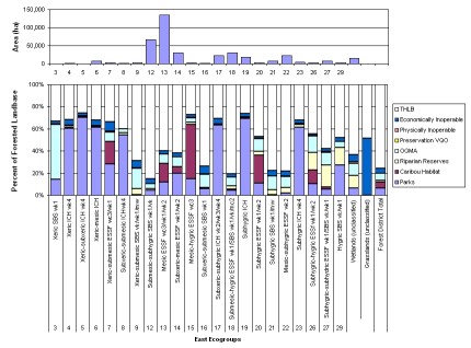
Ecosystem representation analysis is a course-filter approach to biodiversity management, undertaken to determine the abundance, location, and quality of ecosystem groups within the non-harvestable land base (NHLB).
Knowledge of the state of representation of various ecosystem classes allows managers to evaluate representation and ecological risk, assess how the current state compares to biodiversity objectives, and set habitat priorities within the timber harvesting land base (THLB).
Using a combination of GIS data processing and FSOS modelling, the proportion of each ecosystem unit reserved from harvest is examined, to ensure that a full range of ecosystem types is represented across the NHLB. Ecosystem representation data is then used to determine the effectiveness of the NHLB in reducing ecological risk, which is dependent on the quality of ecosystem representation. Knowledge of the degree of risk for certain areas of the land base can assist forest managers in planning and identifying priority areas for biodiversity management.
Forest Ecosystem Solutions Ltd. have conducted a several forest level ecosystem representation analyses, including TFL 30, Fort Nelson TSA, Prince George TSA and Quesnel TSA.
Indicator Forecasting
Forecasting is an activity that assists forest practitioners and decision makers in long-term planning for sustainable forest management, by evaluating the effects of management practices on the desired future forest condition and in identifying practices that will be effective in meeting management targets over the long-term.
Forecasting indicators involves both spatial and non-spatial modelling, for not only does the state of indicators need to be measured through time, their location across the land base must also be identified in order that operational decisions be based in reality.
Through the use of GIS and our FSOS, Forest Ecosystem Solutions Ltd. is able to forecast indicators for a variety of client-defined management scenarios.
Indicator Mapping
The development of an indicator map is the first step for assessing the current status of sustainability within a forest management unit and for designing temporally relevant scenarios or forest management strategies intended to achieve sustainability over the long term.
The indicator map assists in identifying areas that may require the development of best practices, innovation or scenario design as an alternative to current practice in order to mitigate target deficits for indicators. It will provide the essential foundation for the next steps of developing a protocol for a tracking system for temporal reporting on indicators as part of a monitoring program that provides meaningful feedback through adaptive management protocols.
Forest Ecosystem Solutions Ltd. have completed indicator mapping projects for the Vanderhoof, Prince George and Fort St. James Forest Districts, and have undertaken indicator mapping as a component to several other analyses. Some examples can be seen in our map gallery.
Assessing progress towards achieving sustainability means meeting indicator targets across the entire management unit as a whole and is based on contributions from both the NHLB and THLB over time. While all criteria are to be met over the entire planning area to which the C&I apply, they may not apply to all sub-units or be weighted equally throughout the planning area.
Indicator maps can be used to identify areas that may contribute to resource objectives throughout the non-harvestable land base (NHLB) such as parks, riparian reserves and inaccessible areas. Contributing areas within the timber harvesting land base (THLB) can also be identified, including wildlife trees, development of road systems for recreation opportunities, tourism opportunities, commercial botanical product extraction, and the creation of early seral patches.
Understanding the contribution of the NHLB towards meeting targets allow managers to quantify target deficits and thus develop best management practices in the THLB. An analysis of current practices and their impacts on the condition of indicators will ideally show that most, if not all, indicators are sustainable over a credible temporal and spatial horizon.